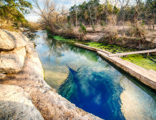
Whether you want to go on a relaxing nature walk or a challenging hike, Sedona has it all. If you are planning to visit Red Rock Country, below is a list of the best Sedona hiking trails. I’m sure one of them will be perfect for your next adventure!

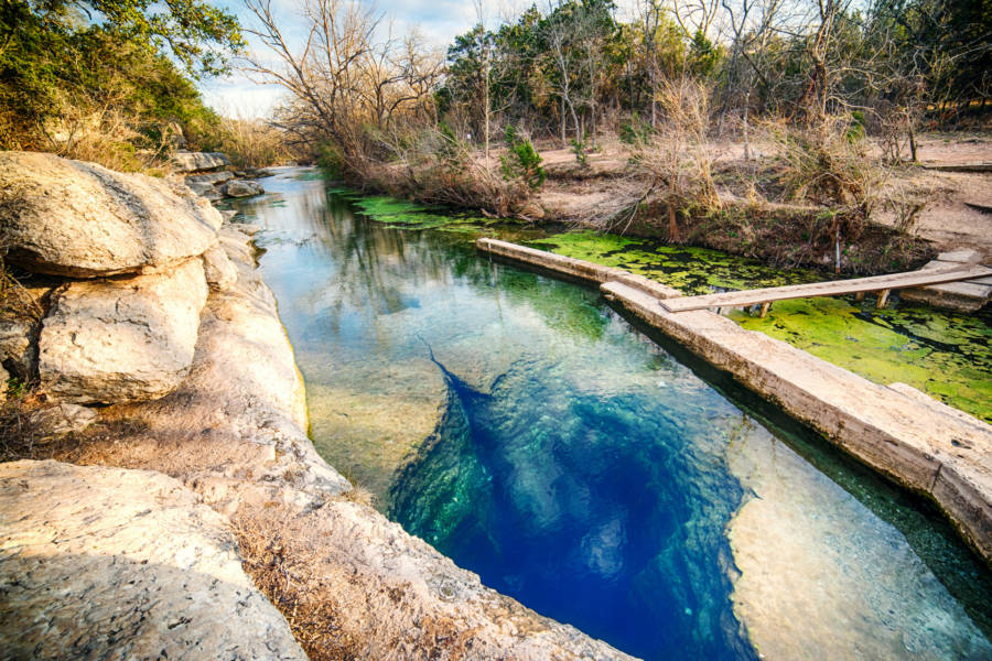
Red Rock Crossing
Level: Easy
Hiking Distance: 2 miles round trip
Trailhead Location: Red Rock Crossing Rd (CLICK HERE FOR DIRECTIONS)
Fee: $11 per car. Cash and check only. Credit cards are not accepted.
Description: Red Rock Crossing is one of the best places to view Sedona’s iconic Cathedral Rock. Photographers from around the world flock here to capture the famous Sedona image.
The best part is that this is the easiest ‘hike’ in Sedona (you honestly can walk this in sandals). The hike begins at the paved parking lot and continues to follow the stream on a sidewalk for about .25 mile. Then, the path becomes a flat dirt road underneath a canopy of trees. Eventually, the trail will come to a rocky opening where the stream curves, and you will have a perfect view of Cathedral Rock and the creek.
Have a picnic, take a dip in the water, meditate, or continue to hike; there really is so much to do at Red Rock Crossing.

Fay Canyon
Level: Easy
Hiking Distance: 2.5 miles round trip
Trailhead Location: The trailhead is across from the parking on Boynton Pass Road (CLICK HERE FOR DIRECTIONS)
Description: A short scenic canyon hike, mostly on soft dirt underneath a canopy of trees. The trail ends in a wash where the mountain wall begins to rise. Keep going another .25 mile for one of the most beautiful views in all of Sedona.
About .5 mile into the hike, you can take a side trail and hike to a natural stone arch. This side trail is not marked, but it will be on the right side with a pile of rocks at the entrance. Just cross over a little wash and head to the north side of the canyon walls. This side trail is steeper, unmarked, and not maintained, so be careful.

Oak Creek Canyon – West Fork Trail
Level: Easy
Hiking Distance: 6.4 miles round trip
Fee: $15 per car. Cash and check only. Credit cards are not accepted.
Trailhead Location: West Fork Oak Creek Trail Parking Lot (CLICK HERE FOR DIRECTIONS)
Description: If you’re looking for an easy scenic hike, this is it. The hike is about a 20-minute drive North of Sedona and one of the prettiest!
This trail captures the true beauty of Sedona: towering red-rock cliffs, lush greenery, wildlife, a stream, and a bit of history from the Old West. The ruins of Mayhew Cabin mark the initial part of the trail, which was built by “Bear” Howard in the 1870s. Fun Fact: “Bear” earned his name by supposedly killing 4 bears with only a knife.
My favorite part about the hike is that you cross the creek 12 times! Hiking in water is always fun! Luckily, the water is only a couple of inches deep, so all you need are water-resistant hiking shoes.


Soldier’s Pass
Level: Easy to Moderate
Hiking Distance: 4 miles round trip
Trailhead Location: Soldier’s Pass Trailhead (CLICK HERE FOR DIRECTIONS)
Parking at Trail: Very limited, maybe only 15 spaces, so be sure to arrive early. Or you can drive East (turn left) down Shadow Rock Drive and park on the side of the road.
Description: Soldiers Pass is a moderately trafficked trail that takes you through a scenic canyon landscape. On this trail, you hike through several arroyos, past the largest sinkhole (Devil’s Kitchen), along the “Seven Sacred Pools”, up to Soldier’s Arch, and then up 509 feet atop Brins Mesa.
If you’re looking for an adventure, check out Soldier’s Arch, a natural arch within the canyon wall. To get here, you will take a side trail (on the right side) about 1.2 miles from the trail parking lot. Since the path is not well marked, keep an eye out for a small sign that is nailed to a tree that says “National Forest Wilderness: Closed to motor vehicles, motorized equipment, hang gliders and bicycles”. Take this path for about .5 mile towards the canyon walls. Be sure to hike with caution, as the trail is steep, unmarked, and unmaintained.


Bell Rock
Level: Moderate
Hiking Distance: 1.5 miles round trip
Trailhead Location: Courthouse Vista Parking Lot (CLICK HERE FOR DIRECTIONS)
Description: This trail is a relatively steep, short climb that ascends the northern face of Bell Rock. The trail to the top is pretty well marked with cairns (rock piles).
About midway, you’ll reach a flat level where you can walk. From here, you have two paths to choose from. If you go right, you can walk around the rock and see views from the southwest. However, you cannot reach the top of Bell Rock taking this path. If you go left, you will find a path that takes you even higher. This way also allows you to climb to the top of one of the spires (experience required).

Devils Bridge
Level: Moderate
Hiking Distance: 4 miles round trip from the Devil’s Bridge parking area, 2 miles round trip from the trailhead
Trailhead Location: Devil’s Bridge Parking Lot (CLICK HERE FOR DIRECTIONS), or if you have 4-wheel drive, you can take Devil’s Bridge Trail Rd.
Description: Devil’s Bridge is one of the most popular hikes in Sedona, so expect to see many other hikers.
If you start your hike from the Devils Bridge parking, the hike to the trailhead is about 1 mile on a relatively flat, wide, dusty road. Once you reach the trailhead, you’ll have a steep hike for 1 more mile to the natural arch. About 3/4 of the way up, the trail splits. The right trail goes to the top of the arch, and the left trail goes beneath the arch. If you hike up to the arch when the trail is wet or icy, be very careful, as you will be climbing some steep natural stone steps without any handrails.
TIP: Try hiking on a Sunday about 2 hours before sunset. This is when I did this hike, and there was absolutely no one on the trail.

Cathedral Rock
Level: Difficult
Hiking Distance: 1.4 miles round trip
Trailhead Location: Begins on Back ‘O Beyond Road (CLICK HERE FOR DIRECTIONS)
Description: Cathedral Rock is one of the most iconic and popular hikes in Sedona. At the end of the trail, you will see some of the most spectacular views Sedona has to offer.
The climb is short and steep to the saddle points, or “gaps,” of Cathedral Rock. The first 300 ft or so of the trail is relatively flat. After that, it is very steep, and at many times you need to use your hands to hoist yourself up the mountain. Once you reach the ‘end of trail’ sign, you have the option to go left and do a little more exploring around the spires!
The first section of the trail is completely exposed, so if you are doing this in the summer, wear sunscreen and be careful. It gets cooler and more shaded as you reach the upper portion of the trail due to the towering rocks around the saddle points.
TIP: Since this is more of a climb than an average hike, good hiking boots are a necessity!

What are some of your favorite Sedona hikes? Are there any I missed? Let me know in the comment below!
Cheers!
Angie xoxo


I love hiking Sedona. I have straight up ventured off and found amazing places but now I will start to mark off some of these hikes. Spaceship rock is a great one to
add to the list too.
This is an awesome breakdown, thank you so much for these helpful reviews!
For the more moderate-difficult hikes here, do you think hiking boots are required or will tennis shoes suffice? And do you need to be an experienced hiker or just an active, fit person? We are looking for some challenging hiking to get a good workout in, but are not necessarily mountain climbers 🙂
Thank you!
So you definitely can do them in tennis shoes if you’re careful. The hike to Cathedral Rock is steep thought and the rocks can be slippery or loose so it’s better to do it with hiking shoes if you have them.
Hi! Loved this article. My boyfriend and I are traveling from Glensdale to Sedona early Saturday morning and we’re planning to get in at least two hikes that day. Do you have any recommendation on what two would be doable/conveniently near each other? We were planning on saving Cathedral Rock for early Sunday morning as we have to head back then.
Hi Allie! I would do Fay Canyon and Devil’s Bridge Saturday. They parking for both is within a mile of each other
Hi Angie…I’m thinking of coming to Sedona in Mid October 2020. Sat-Sat (6 full days). Will be doing a Jeep Tour, a Trail Ride, and maybe another activity in those 6 days. How could I organize the hikes you listed here? I’ll be by myself, so perhaps the day long trail(s) is not safe when alone?
Thanks
Tanis
Hi Tanis! Sedona is a very safe place where you could do all of these hikes alone if you have enough water and are comfortable navigating the trails by yourself. The trails are well marked and very popular so you will typically see a lot of other hikers. The only one that might be more complicated is Oak Creek Canyon since there are river crossings. I’m not sure about organizing a group hike but I bet there are FB groups with fellow hikers either in Sedona or traveling to Sedona.
Loved all the hikes you chose! Great article and amazing pictures!
Really love your article! What do you recommend for 2.5 days? We arrive Friday afternoon and looking to go to airport Mesa that evening, but want to get the most of Saturday and Sunday. Do you think and recommend we can fit all those hikes in two full days?
Hi James, If you’re planning on hiking constantly for those 2.5 days I think it’s possible. All the hikes are relatively easy. The only ones that might take more time are West Fork Trail and Soldiers Pass (because it loops and merges into other trails). For those two, you can hike as far as you want and then turn around. But the others are definitely much quicker.
I would definitely recommend going to Red Rock Crossing, Fay Canyon, Devils Bridge, and Cathedral Rock. These are my favorites!
Hi Angie. Would you recommend Red Rock crossing and Fay canyon together in one half day trip? Me and my daughter are headed to Sedona in the morning, we live in north Phoenix. Great blog post.
Hi Amy, I definitely think it’s doable! I’d start with Fay Canyon and then end at Red Rock Crossing for a nice lunch break before heading back home. ???? Have a fun time!
Hi! I am on my way to Sedona and trying to figure out which hikes I can group together for each day, I want to see them all! We are pretty active and will have 4 full days. What do you recommend?!
Hi Alex! I think you’ll have more than enough time for all of them. 🙂 I would group these together:
Bell Rock / Soldiers Pass
Fay Canyon / Devils Bridge (hike around sunset)
Red Rock Crossing (this really isn’t a hike, more like a walk) / Cathedral Rock (hike around sunset)
Oak Creek Canyon (I am only keeping this separate because it’s a long walk that requires some stream crossing, but honestly you could maybe do this is the morning and any of the others in the afternoon.
Appreciate this article so much! My husband and I are headed to Sedona tomorrow and printed this out for a guide 🙂 I can’t wait to explore!
Great article! I’ll be in Sedona for one day in May and have planned to take advantage of the hikes. I definitely want to do Devil’s Bridge. Could I fit in more than one hike in a day? What would you recommend as a compliment to Devil’s Bridge? I would like to do Cathedral Rock but I’ve heard doing both hikes in one day is too much, especially given the difficulty of Cathedral Rock.
Hi Julia, I definitely think you could do Cathedral Rock and Devils Bridge if you give yourself enough time, bring enough water, and are looking for a challenge. If you don’t hike often or do cardio regularly, it may be too hard (honestly, it would be difficult for me), but it is doable.
If you want an easier hike, I’d recommend Fay Canyon, and it’s only about a 2 minute drive from the Devils Bridge parking lot. If you want to see Devils Bridge at sunset (which I would recommend), hike Fay Canyon first. Fay Canyon is totally flat until the end which you can hike past to that lookout.
This is a fantastic list! Thank you!
I just have a question about the pictures – I’m not sure if the photos and descriptions are paired up together, and if they are, does it go Photo then Description underneath, or is it Description first then Photo underneath? Cause there are a few hikes I definitely want to go on based on the pictures, but I’m just not sure if the name of that hike is above or below the picture and I don’t want to end up doing the wrong hike haha. Just wanted to double check!
Thanks so much!
Sorry for any confusion! It does description then photo underneath. 🙂 For example, for Red Rock Crossing I have the text underneath and then a photo of a grassy area with a tree and cabin with a mountain in the background. Hope that helps! 🙂 Happy hiking!
No worries! Thank you so much, it helps immensely! 😀 I appreciate it!
This blog post was a lifesaver for me! I didn’t get much time to prepare for our recent Sedona trip and there are A LOT of hiking trails, so I was getting overwhelmed with the choices and the planning. This post totally helped me decide on our itinerary quickly. It was super helpful to have photos to reference and details like the level of difficulty and hiking distance. We ended up doing Fay Canyon & Devil’s Bridge! Keep up the super helpful blog posts!
I’m so happy to hear the blog post was helpful! 🙂 You really can’t go wrong in Sedona since all the hikes are gorgeous, but I definitely think you did my favorite 2! 🙂
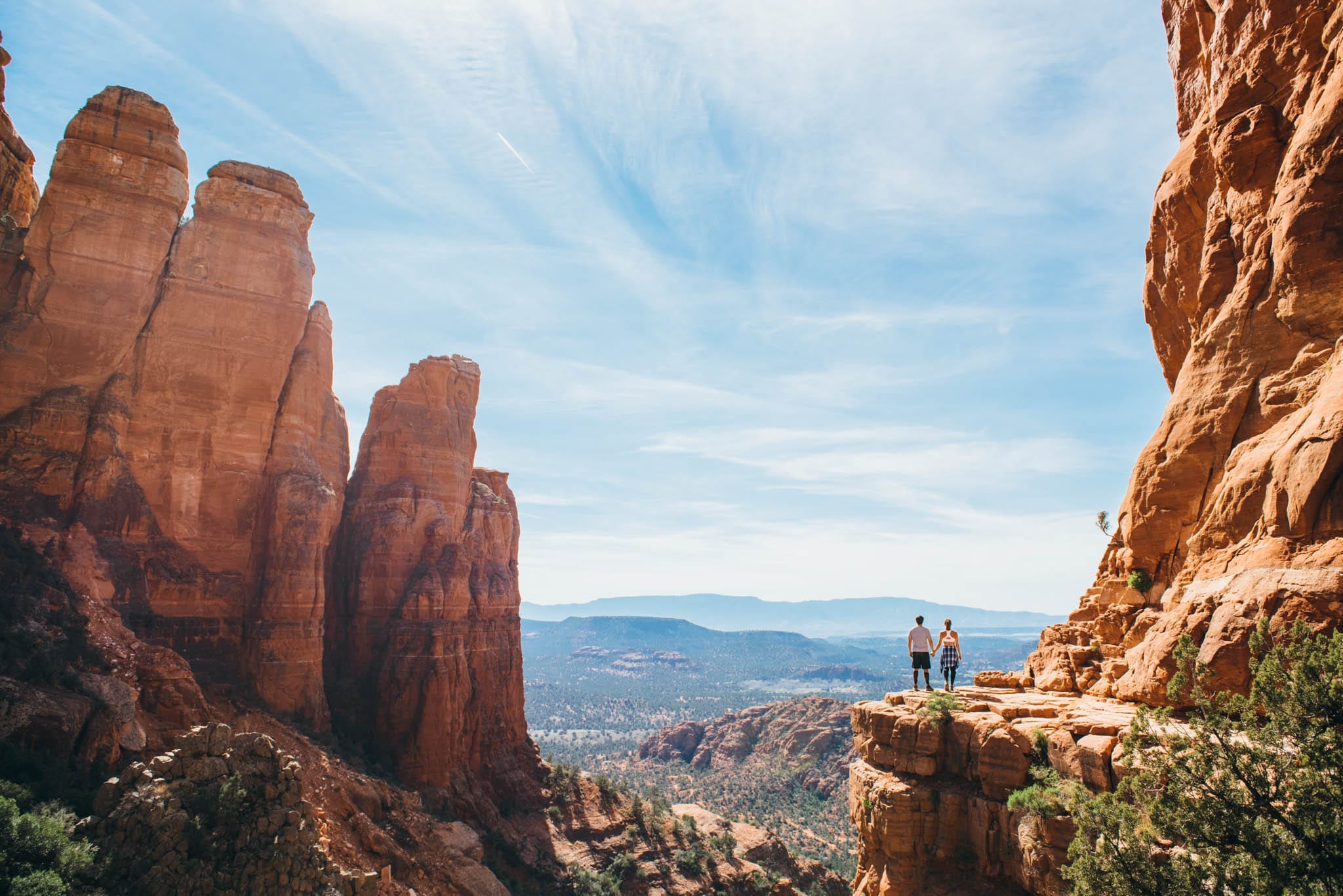
What hike is the picture on the very top from?
It’s from one of the viewpoint on Bell Rock 🙂
Soldier’s Pass in Sedona is one of the best hiking tour in my life. It was incredible. Thanks for such a comprehensive list.
Love your pics so much! You make me want to go out hiking ??
I LOVE Sedona! I hiked here 2 years ago and we did Devils Bridge trail. It was my first trip to AZ from the UK and I fell in love with the place. Would love to go back to Sedona to try some of the other routes you talk about they are so beautiful!
Just another reason to visit arizona again! The devils bridge hike sounds like fun! And inspiring photos as always ?
I was in Sedona over the summer and woke up at 4am to hike out into the red rocks for sunrise. It was absolutely incredible!!! Thanks for such a comprehensive list. It’ll come in handy next time I’m out that way.
Very informative article! Great job Angie ? xx keep it up
I’m following you since a month or two now and I really love all your pictures, you give me sooooo much inspiration!
I really love hiking but I never heard of Sedona, so thanks for sharing this helpful article! It really makes me want to go there now!
I loved Red Crossing! These others I didn’t have time for, but since I plan to return to Sedona next year, I will do them! Beautiful photos, as well ♡!
Thanks for writing this! I’m headed there in a few weeks and plan on hitting up a few of these trails!
Yes girl! I did a few of these trails but the devils bridge one was my absolute favorite! Thank you for posting this because I want to go back and check out a couple more and it seriously helps that you put the level of difficulty and time it takes so I can plan accordingly! Love your work but I already told you that before!
I absolutely love hiking! It’s a more recent love but I love the thrill of reaching the end and admiring the view that you get rewarded with. Places which you can reach only by foot are my favourite. I’ve never hiked Sedona but all the hikes look absolutely stunning. Cathedral Rock sounds totally up my street. I love a good scramble haha. You will absolutely love Norway if you love hiking! The scenery is breathtaking. We did 3 different hikes and loved all of them but Trolltunga was my favourite! Can’t wait to see where you go hiking next Angie!
This makes me want to go and bike over there now! And making me want to go on a hike is not the easiest thing to do.?
This is very informative. As I love hiking and exploring.. this blog post will be very handy for my hiking adventure in Sedona. Cathedral Rock and Devils bridge are definitely the trails I would love to hike. The views are so stunning! Thanks for all the information Angie 🙂 Keep us inspired as usual!
That sounds like quite an advanture. I hope i’ll visit Sedona one day, I’d love to check out all of those places.❤️
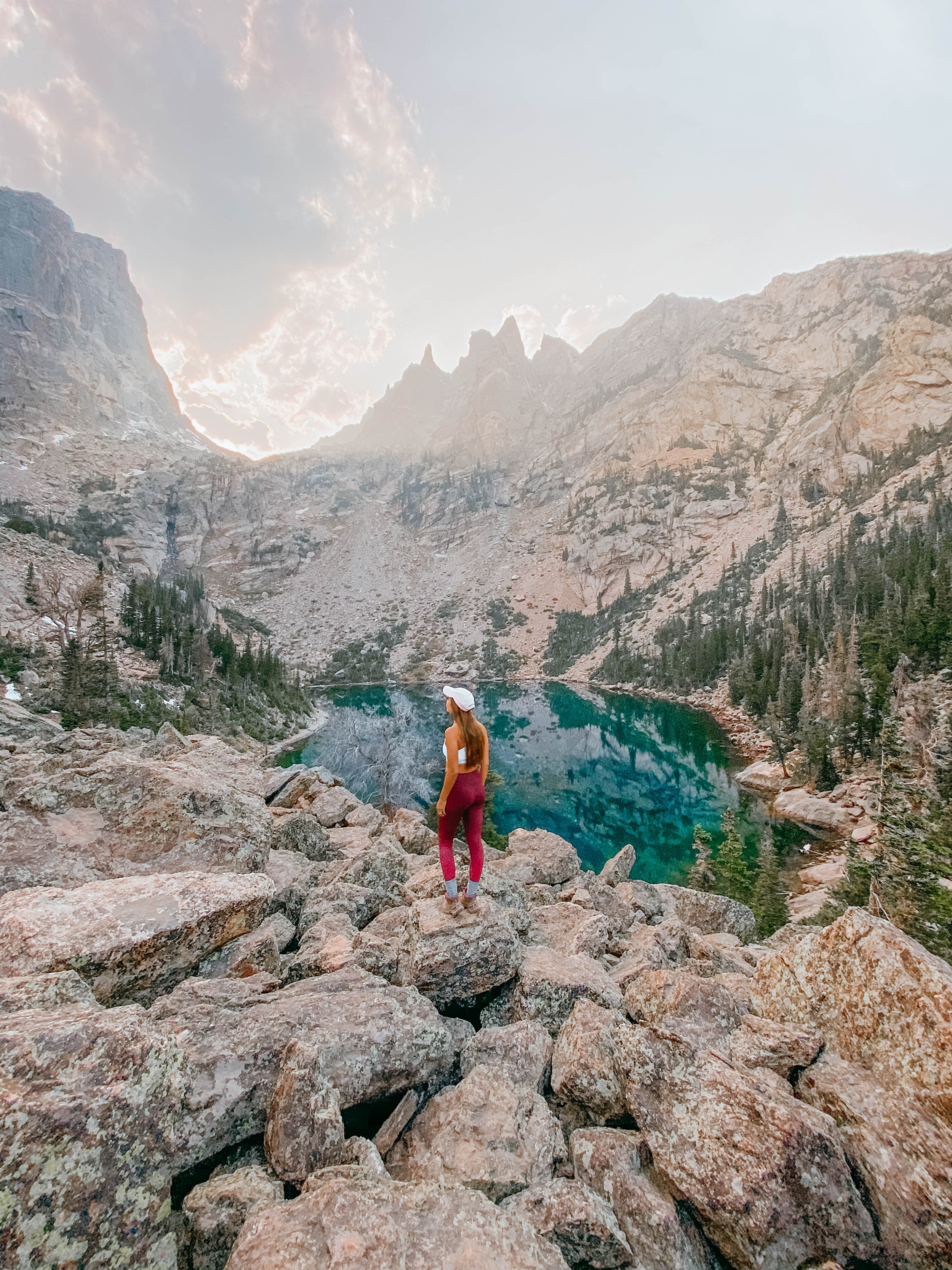
This is an awesome article! Especially for city girls like myself who haven’t done much hiking! When I visit Sedona I will definitely make a point to try the easy hiking trails for the experience and to get some amazing captures! The visuals with this article are stunning! Breathtaking views!